Meteorológiai esélylatolgatások
Pedig a GFS-bõl készül azt írják, csak mire letöltik, és korrigálják a topográfiával, addig már kijön az új futás..
"We use the Global Forecast System (GFS) weather models for our input data. [..]
Our Snow Forecast Maps are calculated by estimating the temperature on the surface (represented by a 1km digital elevation model) using lapse rates derived from pressure and temperature data. Snowfall is predicted wherever this same model forecasts precipitation falling onto ground that is expected to be below freezing on the basis of its altitude and the lapse rate at that point. The quantity of snow is given by the forecast accumulated precipitation, multiplied by a conservative snow:rain factor (8.0)."
Link
Utolsó észlelés
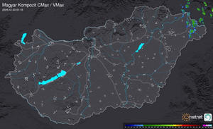
Térképek
Radar
Aktuális hõmérséklet
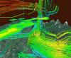
Aktuális szél
Utolsó kép
Lehűlés és csapadék is érkezik
Időjárás-változás | 2025-08-19 12:51
Szabályzat