Meteorológiai társalgó
Hasznos linkek (és egy infó)
>> Sat24 műholdképek>> Sat24 Magyarország mozgó műholdkép
>> Magyarországi radarképek archívuma
>>Tippelek az előrejelzési verseny aktuális fordulójában!
>>Rádiószondás felszállások élő követése!
>>Észlelés (közeli villámlás, jégeső, viharos szél, villámárvíz, szupercella, tuba, porördög, tornádó, víztölcsér, viharkár) beküldése a szupercella.hu-nak!
----------
Képek beillesztése esetén kérjük azokat megvágni, reklámok, mobilok fejléce, stb. csak feleslegesen foglalja a helyet és áttekinthetetlenné teszi az oldalt - a vágatlan képek ezért törlésre kerülnek.
Fotózáskor kérjük a mobilt fektetve használni, egy keskeny de magas kép egyrészt szintén sok helyet foglal, másrészt a kép sem túl élvezetes.
Köszönjük az együttműködést és a megértést.

Szerintük nem egyértelmű....
De ez amúgy nagyon jó előrejelzés, és eddig stimmel is (Dec 2. hetére amit írnak).
Utána ők is jelzik, hogy kezdődik az előrjelzési káosz Link
Link
Karácsony környékére jelentősebb, kiterjedt lehűlést ír Skandináva környéki központú AC mentén elinduló ÉK-i áramlás nyomán:
" Despite no low-pressure area is seen over northwestern Europe, the higher pressure over Scandinavia does tell the tale. A high-pressure area spins clockwise, meaning that it would promote northerly/easterly flow over eastern Europe. The temperature forecast does show colder than normal temperatures over central and parts of eastern Europe. Such a pattern would bring somewhat winter conditions over Europe if the cold air source zone from the north would be could enough at this point in time. Over western Europe, we also see a colder area, which is likely sourced from a low-pressure system over northwestern Europe."
De ez amúgy nagyon jó előrejelzés, és eddig stimmel is (Dec 2. hetére amit írnak).
Utána ők is jelzik, hogy kezdődik az előrjelzési káosz
LinkKarácsony környékére jelentősebb, kiterjedt lehűlést ír
Skandináva környéki központú AC mentén elinduló ÉK-i áramlás nyomán:" Despite no low-pressure area is seen over northwestern Europe, the higher pressure over Scandinavia does tell the tale. A high-pressure area spins clockwise, meaning that it would promote northerly/easterly flow over eastern Europe. The temperature forecast does show colder than normal temperatures over central and parts of eastern Europe. Such a pattern would bring somewhat winter conditions over Europe if the cold air source zone from the north would be could enough at this point in time. Over western Europe, we also see a colder area, which is likely sourced from a low-pressure system over northwestern Europe."

Havazás előrejelzés

Utolsó észlelés
Térképek
Radar
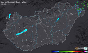
Aktuális hõmérséklet
Aktuális szél
Utolsó kép
Melegfront hoz havazást, ónos esőt, fagyott esőt és enyhülést is
Időjárás-változás | 2026-01-11 10:28
Szabályzat